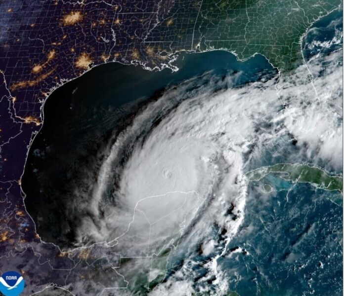
Hurricane Milton will make landfall as a Major Hurricane tonight in Florida, all flights in and out of Florida are discontinued until further notice. Here is what we know from the NHC:
For your Close to Home LIVE radar find your county here
Hurricane Milton Discussion Number  18
NWS National Hurricane Center Miami FL       AL142024
1100 AM EDT Wed Oct 09 2024

Milton's structure has begun to change due to the onset of strong
southwesterly shear, which UW-CIMSS is analyzing to be 30-35 kt.
The cloud canopy has become more asymmetric with dry air
infiltrating the western side of the circulation, and the eye has
also become cloud filled.  The NOAA and Air Force Reserve
Hurricane Hunters observed that the eye is open to the south, and a
very recent dropsonde indicates that the minimum pressure is up to
931 mb.  Milton's intensity is therefore set at 125 kt on this
advisory.

Deep-layer shear is expected to increase further today and this
evening, and continued weakening is anticipated.  However, since
Milton only has another 12 hours or so over water, it is expected
to still be a major hurricane when it makes landfall tonight.  The
NHC intensity forecast lies between the statistical-dynamical models
and the consensus aids at 12 hours, meaning that Milton is likely
to be a category 3 or 4 strength at landfall.  A slow decay in the
winds is expected after landfall, but Milton is anticipated to move
off the east coast of Florida on Thursday still as a hurricane.  On
another note, Milton is expected to begin interacting with a front
later this evening, which is likely to cause the wind field to
expand on the hurricane's northwestern side.  This will likely
cause very strong, gusty winds to occur even to the north of where
Milton makes landfall.

Milton is moving quickly toward the northeast (035/15 kt).  The
track models insist that the hurricane will continue to move
northeastward but slow down through the rest of today, with a turn
toward the east-northeast occurring overnight.  The NHC track
forecast maintains continuity with the previous predictions, lying
near the northern boundary of the guidance envelope and close to
where the raw model fields bring the center onshore.

We would like to emphasize that Milton's exact landfall location is
not possible to predict even at this time, particularly if the
hurricane wobbles during the day and into this evening.  Even at
12-24 hours, NHC's track forecasts can be off by an average of 20-30
nm.  Since storm surge forecasts are highly sensitive to the exact
track, this means that the realized storm surge heights across the
Tampa Bay region and south may vary widely, and there will likely be
a noticeable gradient of surge heights to the north of the landfall
location.  However, the risk of devastating storm surge still exists
across much of the west-central and southwest coast of Florida given
the size of the storm and the uncertainties in exactly where
landfall will occur.

Finally, damaging winds, life-threatening storm surge, and heavy
rainfall will extend well outside the forecast cone.  This is a very
serious situation and residents in Florida should closely follow
orders from their local emergency management officials.  Evacuations
and other preparations should be completed over the next couple of
hours.


Key Messages:

1. A large area of destructive storm surge, with highest inundations
of 10 ft or greater, is expected along a portion of the west-central
coast of the Florida Peninsula.  If you are in the Storm Surge
Warning area, this is an extremely life-threatening situation.  The
time to evacuate, if told to do so by local officials, is quickly
coming to a close.

2. Devastating hurricane-force winds are expected along portions of
the west coast of Florida, where a Hurricane Warning is in effect.
Milton is forecast to remain a hurricane while it crosses the
Florida Peninsula and life-threatening hurricane-force winds,
especially in gusts, are expected to spread inland across the
peninsula.  Preparations to protect life and property, including
being ready for long-duration power outages, should be rushed to
completion.

3. Heavy rainfall across the Florida Peninsula through Thursday
brings the risk of catastrophic and life-threatening flash and urban
flooding along with moderate to major river flooding, especially in
areas where coastal and inland flooding combine to increase the
overall flood threat.


FORECAST POSITIONS AND MAX WINDS

INIT  09/1500Z 25.8N  84.3W  125 KT 145 MPH
 12H  10/0000Z 27.0N  83.0W  110 KT 125 MPH
 24H  10/1200Z 28.0N  81.1W   75 KT  85 MPH...INLAND
 36H  11/0000Z 28.7N  78.3W   65 KT  75 MPH...OVER WATER
Subscribe to our Newsletter!


